This one is for William Tinus.
The Lost Creek Wilderness is located about 2 hours southwest of Denver. When Jay came to visit in 2006, we did an overnight hike in the area, but my friend Charley said we had not reached the best part. I put it on my list to get back to.

This past July 4th, I finally made it back. The plan was to take KLS out on her first multi night backpacking trip. We weren't sure if we were going to do the bigger or smaller loop. We were going to decide on the way depending on how we were feeling.

On the way there, you drive through the area that was destroyed during the Hayman fire, Colorado's largest wildfire. It is terrible how the forest can be destroyed so quickly, but amazing to see its charred remains scattered among the first shrubs growing back.

We started hiking from the Goose Creek trail head around 8am and opted to go clockwise around the loop and I highly recommend anyone else do the same because of the descent on McCurdy Park Trail toward Goose Creek Trail on the northwest part of the loop from the T-intersection with McCurdy Trail. I know we descended for almost an hour and I can't imagine how long it would take to get up. It probably isn't as bad as I think, but when I go back, I'm going counterclockwise again.

Anyway, at 10am, we hit the junction of the Lake Park Trail with Hankins Pass. We switched onto Lake Park and we had my first major bout with mosquitoes in Colorado. I've certainly found a few before, but only a couple, not enough to require bug repellent. The melt water from the big winter had given them a lot of extra water to reproduce in. In this part, we finally left the aspens and started climbing up to a dryer area without any mosquitoes. By noon, we reached the high point of the hike around 11758'. (Future reference, there is a great dry camping spot here IF you pack in enough water.). Take the time to explore here.


At 2pm, we hit the crossroads to decide if we were going to take the
long or short way. I can't remember the reasons, but probably to be safe
since it was the first outing of the season, we went with the short
route. Future note: there was a little bit of water just before the
intersection and that was the last water we saw for 3-4 hours. After
the crossroads, we started a LONG, LONG descent. It rained, but luckily
we stayed pretty dry in the woods. Once you clear the woods, you begin
the BEST part of this hike.


I don't think anything but being there can convey the best part of this hike. Around 5pm, we crossed our first creek since the last trail intersection and it would make a great campsite. I hope to make it back there one day. It was early though, so we kept going. Around 6pm, we finally pulled into our campsite for the night. We were at one of the spots where Lost Creek rises back above ground. It is a stunning spot, that I managed to not take a single great photo of. You basically walk down a slope coming from either side to the creek and it opens up around the water surrounded by a few great rock formations. The only bad part about this campsite was trying to find a good tree to hang your food bag from.


The next morning, we got moving again through the beautiful terrain. I think we were moving by 7am. In this area, you start to pass through some dense woods. I think a number of them were aspen trees. We turned right on the Goose Creek trail at 8:30am and continued to be amazed the scenery. At 10am, we took a side trip. The one hour detour took us to an old mine, abandoned buildings, and a dense set of rock formations. I'm not sure, but it seemed like you could only walk in the way we did (trail or not) and was very isolated. If you were willing to dry camp, I think it would a great spot. The walk to the creek might be a mile. The main trail has a number of great campsites, but it is also more crowded. The closer we got to the car, the more people we saw. We saw enough people and decided that we decided to just head out that day. We were back at the car by 1pm and on our way home.

I had wanted to go camping for two nights, but near the end my head just wasn't in it. It is has always been a weird mental state for me. I love being out in the woods, but when I am close to car, I am always excited to get back home. With so many people around and 26 miles under our belt, I was very happy to get home and take a nap.

The Lost Creek Wilderness is located about 2 hours southwest of Denver. When Jay came to visit in 2006, we did an overnight hike in the area, but my friend Charley said we had not reached the best part. I put it on my list to get back to.

Lost Creek Wilderness sign
This past July 4th, I finally made it back. The plan was to take KLS out on her first multi night backpacking trip. We weren't sure if we were going to do the bigger or smaller loop. We were going to decide on the way depending on how we were feeling.

Hayman fire damage on the way to the Lost Creek Wilderness
On the way there, you drive through the area that was destroyed during the Hayman fire, Colorado's largest wildfire. It is terrible how the forest can be destroyed so quickly, but amazing to see its charred remains scattered among the first shrubs growing back.

Pine(?) tree branch and cone.

Up to the top of our loop.

Descending into the best part of our Lost Creek loop (on the north part of the McCurdy Park Trail).

You take the high road, she'll swim the low.

Sabah is not happy about her photo shoot!
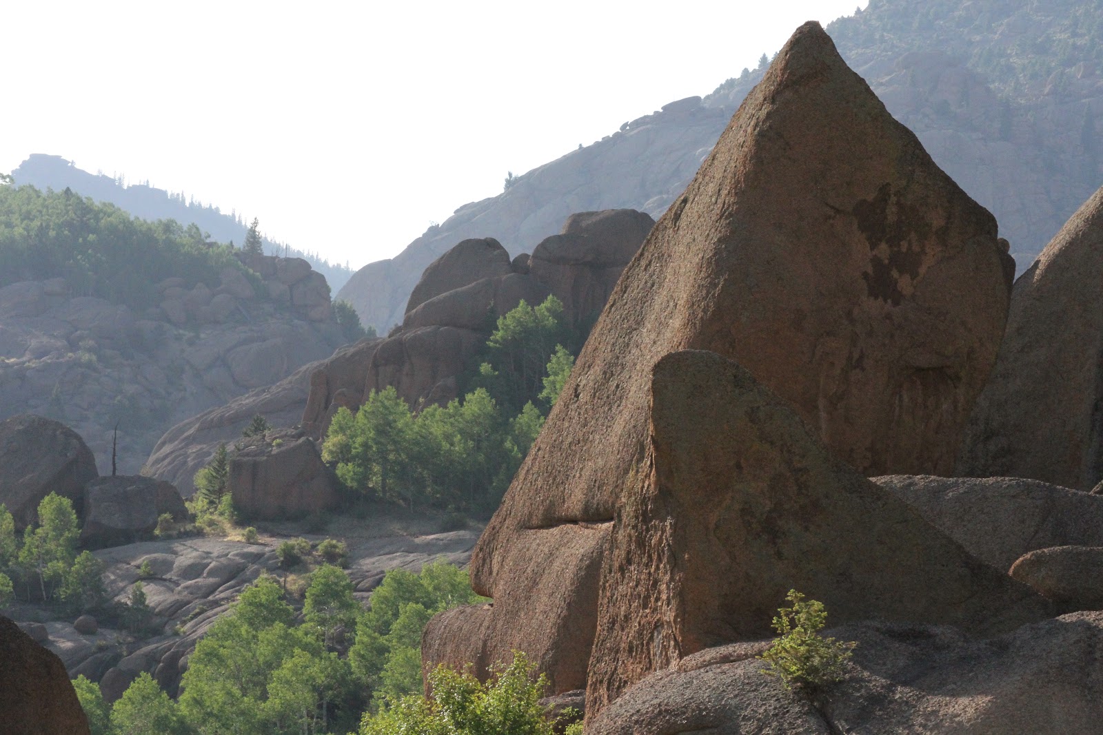
It was neat to have seen this pyramid rock almost an hour earlier from a view point and then descend to it.

More great rock formations. Granite?

The Lost Creek campsite, I think.

Sabah looking for something at our Lost Creek campsite.

Aspen trees.

Abandoned building on out side trip.

Columbine flower.

Your pine tree is a bristlecone pine. The rocks are all granite in this part of Lost Creek WA.
ReplyDeleteThanks for your pix,
Riversong
Did you mean to say clockwise? Based on reading this you started from Goose Creek TH and went west on Hankins Pass Trail, then headed North on Lake Park trail to McCurdy then to Goose Creek trail.
ReplyDeleteYes, JohnJ :)
ReplyDeleteEditing now.