Just over a month ago, NASA found something in Antarctica that no one ever expected to find, two three inch shrimp under 600 feet of ice, 12.5 miles from open water. Scientists have always assumed that only microbial life could live under such harsh conditions. This calls that assumption into question and forces us to ask about what other complex life could exist in similar conditions throughout our solar system. One of the cooler parts about the discovery and article for me is that they feature quotes from a scientist that I've worked with in Antarctica. " Stacy Kim—one of the biologists in NASA's ice science team—says that they don't really have a clue about what is happening down there, but that it is highly improbable that these animals swam all the way from open water."
Terra Nova Bay (photo by C. Poirot)
A few weeks ago, South Korea announced that it will be building their second Antarctica research station at Terra Nova Bay. Their first, King Sejong Base, holds 17 researchers. The new station will hold 60 researchers and their support staff. Terra Nova Bay is located a few hundred miles from McMurdo and the existing Italian base there, Zucchelli Station, has sometimes served as a back up air field for the United States Antarctic Program. The new base will take a year to build, cost $88.4 million, and should be completed by 2014. Once complete, Korea will be only the ninth country to operate more than one base in Antarctica. Currently, they are twenty countries with stations on the continent.
Finally, a friend showed me this clip of Antarctica research to be . . .
The first of many river crossings on the TranzAlpine.
After leaving our hostel, Celeen and I were headed for Greymouth. We dropped our rental car in Westport and then were able to hitch all the way down to Greymouth with one ride. A Dutch couple picked us up in the sunshine, took a rainy rest stop at the Pancake Rocks, and then dropped us off right at the train station. They were doing a whirlwind tour of New Zealand. Despite the photo above, Greymouth was named for a politician, not for the states of the sky.
Farmland and beech forests.
From Greymouth, we were hoping to catch the TranzAlpine train to Christchurch. The 223.8km journey takes just a little over four hours and would get me home just in time for ultimate practice. The journey starts on the west coasts, crosses the Southern Alps, and then descends to the east coast. It is supposed to be pretty spectacular and we thought it would be a fun way to travel instead of the bus that whips around every corner.
The Southern Alps.
A mostly empty river valley in the Southern Alps.
We started out our journey by taking advantage of traveling by train instead of bus. We used our table to comfortably make a lunch of mozzarella tomato basil baguette sandwiches at our seats. We were so hungry. They were so good. After we got moving, we found a set of seats that were empty so we spread out. The start of the journey was rainy so we didn't go out to the open air car. I might have even napped.
Fun cloud formations.
Whipping by the scenery.
As the journey progressed, the scenery and weather improved. Typically, the west coast is rainy and the Southern Alps create a rain shadow for the drier east coast. On our journey, the sun came out and was shining. When it did, Celeen and I moved to the tiny open air car for the rest of the journey. On the TranzCoastal trip, they had a full sized open air car. For this one, they had three times as many people but only two small open air cars. It was great to be out smelling everything whip past and not looking through a window.
Arthur's Pass looking west.
Celeen at Arthur's Pass looking southeast.
We took a quick stop at Arthur's Pass to let more people on the train. It was beautiful. The sun was blazing and it might have even been hot. Celeen and I had both hiked up there before, but it was neat to travel through by train instead of car. It took us into new areas. On the way out of Arthur's Pass, we saw all these trees with bright white blossoms and a new river gorge.
Mountains.
Our ride.
After the gorge, we slowly descended out of the mountains to the farms on the Canterbury plains. They are so green and remind me a lot of Pennsylvania. The train was great. I guess you could see a lot of the same scenery by car, but then the driver doesn't get to enjoy it as much. After bicycle, I think the train is my favorite way to travel. Ride the rails to trails!
After a wonderful rainy night at the Old Slaughterhouse, we caught a ride to Westport. Our intent was to hitch down to Punakaiki to see the Pancake Rocks. However, it was raining and we lost motivation for that in a hurry. We rented a car instead and took off for the Cape Foulwind seal colony. It is the best seal colony I've ever been too because there were so many pups and they were active. I have never seen seals move so much. Absolutely amazing!
First, let's play count the seals again.
Seal colony video
Photos would not do the seals justice so I was trying to get a couple videos of them moving around. After my first couple, I remembered that my video camera had a bunch of extra features that might make for better footage. There was a video stabilizer, filming in HD, and digital zoom. The digital zoom made things a little grainy, but it was great to be able to zoom in so much. The best version of the footage is below.
Seal Colony video zoom
Penguin crossing sign.
After being entertained by the seals, we headed off for the Pancake Rocks at Punakaiki. It was a long, wet drive. When we stopped to eat, our server didn't think we could finish two grilled cheeses and two baskets of fries. He was very wrong. We housed. I think we were still super hungry from walking the Heaphy. Anyway, after refueling our bellies, we got super lucky and the sun came out.
Pancake Rocks
Arch
The pancake rocks were neat. They are layer after layer of rock. When you zoom in close enough, you can easily imagine Vermont's finest being poured over them before you throw them in your belly. The problem with that is that you pretty much can't buy maple syrup in New Zealand. Also, most Kiwis don't know what pancakes are!!! I'm kind of confused how one of their tourist attractions is called Pancake Rocks then, but it is. Maybe an American was involved.
Blowhole
More Pancake Rocks.
Use your imagination, what do you see (hint, nose on the left)?
Other than just being neatly layered, the pancake rocks have eroded to create a spectacular coast line. There are huge arches, blowholes that shoot a ton of water up into the air at high tide, gnarly rock formations, and formations that your imagination might find animals or faces in. I'm not sure I'd recommend that someone make a special trip to see the rocks, but they are definitely worth a visit if you are in the area.
After the Heaphy track, our plan was to go to the Old Slaughterhouse about 20 minutes north of Westport. Annie had recommended it to me a few years ago and I've kept the idea tucked away in case I ever was over there. I didn't really know what to expect. I hadn't ever seen a place that Annie recommended before. Our ride dropped us off there and a sign said "Accommodation, 10 minute walk." We started trudging up the forested hill. It was steep. It had a lot of switchbacks. When we finally arrived at the top, there was no one around except a purring cat. A sign on the door said "We aren't far away, come in, make yourself some tea, make yourself at home" or something like that. Celeen and I went in and did just that. We settled in to a wonderful lunch on the porch overlooking the sea.
Old Slaughterhouse's balcony
After a couple hours, Dave, who owned the place, came home from a walk. He was incredibly welcoming. He had been a sheep shearer for thirty years and when he was in Ireland, he discovered hostels and realized he wanted to spend the rest of his life running one. His son and him spent two years building the three buildings that make up the Old Slaughterhouse. They used a ton of wood in a very open layout. This is definitely the type of place I hope to live in one day. I am told that it is off grid except for the telephone. They get major supplies up the hill with an ATV. One building has two double rooms. Another has a triple and a six-person bunk room. The main building is their private quarters, the communal kitchen, bathrooms, and living space. It is brilliant. Their kitchen island is made out of an Australian hardwood that was being replaced from the telephone poles on the road by their house. They have a hammock. When Dave's wife got home, it was even more brilliant. She brought along their three dogs, two giant labs, and a happy mutt.
Old Slaughterhouse's main building
While we had only planned to stay for a night, we loved it so much that we stayed for two. It was peaceful. It overlooks the Tasman Sea. It was too cloudy to have a great sunset either night, but I can imagine they get some great ones. The dogs loved being pet as much as I loved petting them. I'm definitely going back some day and could encourage you to do the same.
I think I have my loose flights from now until I get home: Friday, April 9th - Sunday, April 11th Wellington, NZ
Monday, April 12th Depart: 1:30 PM Christchurch, New Zealand Arrive: 2:50 PM Sydney, Australia
April 15-20th Cairns, Australia and Great Barrier Reef if I can make it happen.
Wednesday, April 21st Depart: 7:40 PM Sydney, Australia Arrive: 9:25 AM Honolulu, Hawaii, USA
April 21st-23rd Big Island, not booked yet April 24th Oahu April 25th-27 Kauai, Na Pali coast, not booked yet Wednesday, April 28, 2010 - American Airlines 298 Depart: 9:00 PM Honolulu, Hawaii, USA Arrive: 5:15 AM Los Angeles, California, USA
Thursday, April 29, 2010 Departs 8:15 AM Los Angeles, California, USA Arrives 2:15 PM Chicago, Illinois, USA
Thursday, April 29, 2010 Departs 4:25 PM Chicago, Illinois, USA Arrives 5:25pm Wausau, Wisconsin, USA
Thursday, April 29th Sleep in Wisconsin Friday-Saturday, April 30th Drive to Princeton, NJ for Metro East Regionals.
Tentative road trip: May 3-5 NYC May 6-7 Philadelphia May 8-10 Massachusetts May 11-12 Danville, PA May 13-15 Baltimore/DC May 16-20 Pittsburgh May 21-23 Detroit May 24-27 Wisconsin May 28-31 College Nationals June - head towards Denver, CO, possibly via Idaho and Glacier National Park.
June 25th - Drive to Wisconsin June 26-July 10 Prague for World Club Champs of Ultimate. July 10 - August ? Bike tour of Adriatic Sea? August - Spent a lot of time with Sabah.
The Heaphy Track is the longest Great Walk in New Zealand. It crosses from the eastern side of the Southern Alps over to the west side at the South Island's northern tip. It is also an old Maori trail used to transport their canoes from one side to the other. Since it was a multiday trip, I wonder why they didn't just canoe around the top. Maybe the sea conditions were bad. I don't know.
An overlook of the mountain range we would be crossing.
The Heaphy Track is the other hike that I really wanted to do, but didn't, last time I was in New Zealand The start and finish are almost 300 miles apart, which was just too far apart. You can hire a shuttle to get back, but I was cheap and didn't want to do that. This time, I had a little extra cash, no car to get back to, and another reason to be that far north on the west coast.
On top of Mt. Perry, looking for a view of . . . anything (photo by Celeen).
I was a little anxious about this hike. I was taking Celeen out on her first multi-night hike. She had tried one before, sprained her ankle, and didn't react as well as she could of. She doesn't like it when she doesn't have choices. I'm not always the most patient so I was a little worried that I'd get cranky. Other than a few hiccups, I had nothing to worry about. Celeen did great.
Looking down the Perry Saddle at sunset from Mt. Perry.
This hike was unlike any other I had done in New Zealand because we did all of the climbing on the first day. After climbing up 915m of silver and red beech forest, it would almost all be flat or downhill. I'm not sure if I like that, but it was nice to do the hardest part while we were fresh. Of course, it wasn't nice to do the hardest part while we were fully loaded. Our walk up was the definition of partially cloudy. We had a little bit of sun squeezing between the clouds. It was dry, which is expected of the eastern slope. When we got to the top, we whimsically decided to do a recommended side trip up Mt. Perry. It was a mixed bag. We mostly saw clouds pushing in from the west obscuring everything, but there were some great views and a great sunset mixed in.
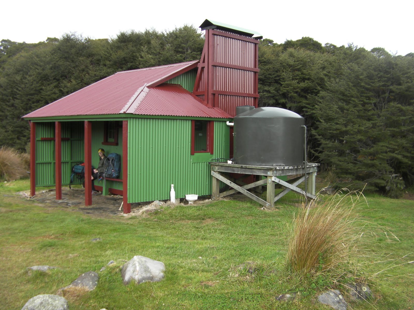
Our lunch stop, Gouland Downs Hut.
Our second day started out misty and stayed that way. It felt like we were walking in the clouds the entire day, which was not surprising. We were walking on a flat plateau over to the western slope which is notoriously rainy. We took our lunch at a quiet little hut that we had hoped to camp at to see kiwis, but it was already booked. Instead, we had to settle with seeing this weka wonder through camp looking for food.
Weka
Just past the Gouland Downs Hut, we were able to explore a couple small limestone caves. Then, we crossed a large creek and moved on to the heart of the plateau. The plateau, probably isn't a plateau by definition. It has mountains on both sides. I don't like the word downs, but it might describe it more accurately. The hike took us away from the fern and beech forests and into a giant area filled with tussocks, flax, streams, and swing bridges to cross those streams. Every plant was dripping wet from soaking up water from the mist. So were we. I don't remember a single animal.
Swing bridge
The tussock downs we would cross.
A close up of the dew on everything (photo by Celeen)
One of the many creeks in the tussock downs that are prone to flooding.
Sand fly infested rest stop.
Our campsite at James Mackay Hut where we were expected to have gale force winds.
Our second night on the trail was one of the most interesting nights. Our warden would not stop talking about the weather forecast for terrible rain and gale force winds. When we asked about why all of the tents sites were built on wooden platforms, he just answered you'll see once the rain comes. Apparently, it floods.
Descending to the Heaphy River.
Walking across a swing bridge.
Another swing bridge.
The storm didn't come while we were asleep. The next morning, we were told to expect it by late afternoon. We had two areas to cross that flood frequently so we got up extra early to try and get to shelter before the worst came. The first part of the hike was a descent to the Lewis Hut on the Lewis river. Along the way, we saw so many varieties of moss and watched the canopy trees go from beech to rimu and huge nikau palms. They palms were huge. After the Lewis Hut, we joined up and kept crossing the Heaphy river on our way to coast.
A dead nikau palm leaf and me (photo by Celeen)
When we finally got to the Heaphy Hut, we breathed a sigh of relief. We were drenched, but had not been dumped on. Thinking back, I'm not sure a dumping would have really changed anything. We took a long lunch break and during that time the rain came down hard. We were supposed to continue on to the next shelter, but the ranger had told us that the Heaphy Hut was the crown jewel of the hike where the Heaphy River crashed into the Tasman sea. The hard rain wasn't convincing us to move on either. We took a quick stroll in the woods to see how much wetter we would get and decided to push on.
West coast forest.
As we walked on, our choice was rewarded. The hard rain let up and then, unbelievably, the sun started to wink through the clouds. We could not believe our luck. We walked along the beaches to our final, and best, night on the trail. We stopped at a shelter that was sand fly infested. We had considered sleeping in the shelter and letting the tent dry out, but the sand flies disagreed. We set up on the beach, laughed at the hundred sand flies gathered on the tent, and watched a great sunset which was only out done by the clear skies and meteors we saw that night. It was the only clear night we had. We heard waves crashing while we slept. I love the beach at night.
Invasion of the sand flies.
Our beach on the final night got just a little bit of sunshine.
Sunset on the beach
Final morning's walk.
Because we had walked extra the day before, we had a very short walk in the morning. It started out misty, but got warmer and sunnier as they day progressed. Just as we got to the final section, it cleared up making the end of the trail seem like an oasis even though the wet days weren't that bad. I just love sunshine.
Giant tree that a ton of other plants were growing on.
Last look back over the coastline that we had walked.
The Heaphy Track was good. At first thought, I think some of the other tracks I have done are better, but I think my bias towards those tracks might have to do with the amount of sun I saw on those tracks. The Heaphy was a great place for Celeen to learn. For non-learners and learners alike, the amount of diversity from one side of the mountains to the other is just amazing. I wish I knew more about the plants to appreciate them more.
The Kohaihai River meets the ocean.
When we got to the end, we had a couple hours to pass before a cheap transport option would arrive so we set off to explore. On our way to the Zig Zag trail which I can only imagine is entirely too many switchbacks, a man was dropping off a hiker and offered to give us a ride to town. We were just hoping for a ride to Karamea and then would figure out how to get to that our night's lodging near Westport later. However, our driver was actually going to Westport, so we skipped Karamea and went right to our hostel, the best hostel I've ever been in, the Old Slaughterhouse.
The end of the Heaphy Track.
Heaphy Track (78.4km) by the numbers (map) Day 1 (17.5km):
Brown Hut to Perry Saddle Hut 17.5km
Day 2 (24.2km):
Perry Saddle Hut to Gouland Downs Hut 7km
Gouland Downs Hut to Saxon Hut 5.4km
Saxon Hut to James Mackay Hut 11.8km
Day 3 (28.6km):
James Mackay Hut to Lewis Hut 12.5km
Lewis Hut to Heaphy Hut 8km
Heaphy Hut to Katipo Creek Shelter 8.1km
Day 4 (8.1km):
Katipo Creek Shelter to Kohaihai River Shelter 8.1km
One of many spectacular views from the TranzCoastal Railway.
After running practice on Thursday night, I ran home to pack up my gear to go hike the Heaphy Track. I had a day and a half to get there, so I wanted to try something new. The train wasn't too much more than the bus so I signed up to take the TranzCoastal Railway from Christchurch, through Kaikoura, and up to Blenheim. Most people take it all the up way to Picton to catch the ferry over to Wellington. I'd driven this road a couple times, but thought the train would be a fun change. It was.
One of my favorite sites on the trip was this classic car cruising the coast.
The morning was pretty quiet. I sat in my seat and watched the scenery of towns and quick glimpses of sunrise pass by through the window. However, when we were almost to Kaikoura, everything was getting spectacular so I moved into the open air car to experience the scene instead of just watching it. It was like getting out of a car and onto a bicycle. The ocean came into view. The mountains sprang up. We saw basking seals on the shore. We saw corralled fish jumping out of the water to dodge dusky dolphins. It was warm. It was wonderful and stayed that way for the rest of the trip.
A video tour of the open air car.
Traveling by train is always a treat. This trip was no different. I don't know why, but I've always hated buses. Back in Denver and New York, I'll happily ride the train all day. I avoid the buses. I'll bike to the train instead. I don't know why. It is weird, but it works for me.
Baldwin Street, the steepest in the world, in Dunedin, NZ
On the way back from Stewart Island, we took the same route, but made quite a few pit stops along the way. Our first stop was in Dunedin to see the world's steepest street, Baldwin Street. It has a 35% grade. For the sake of accuracy, and a little city pride, Pittsburgh has Canton Avenue in Beechview that has a 6m section at 37%. However, that section is so short that it doesn't count for the world's steepest. Just like at Red Rocks Amphitheater in Colorado, it is a tradition to walk up and then back down. My Achilles was still bothering me so I didn't walk it which gave Hannan a happy excuse to drive up. The way up was easy. The way down was a little harder. Hannan told us about an annual event, the Undy 500, where engineering students buy cars for under $500 and drive them from Christchurch to that street in Dunedin with lots of pub stops in between. Lots of the cars don't make it to Dunedin, let alone up the street.
This is like Where's Waldo, but you count the seals.
A New Zealand fur seal way out of the water.
Just a little scratch.
This seal had great big expressive eyes that I adored.
Our next stop was at the Moeraki lighthouse to see yellow-eyed penguins. However, we also got to see a ton of New Zealand fur seals. They were quite similar to the Weddell seals in Antarctica that just lay there all day. It can be hard to find them against the dark rocks. However, these guys would at least acknowledge our presence from time to time. It is funny how I can love a creature who does so little. When you do get to see them moving about, especially in the water, they are precious and playful.
Moeraki Lighthouse.
Two posing yellow-eyed penguins.
Penguin jail, sealed in by wire, has treated some of the penguins rough or the youngster is just molting in the breeding ground.
Yellow-eyed penguin near the Moeraki lighthouse.
Yellow-eyed penguin near the Moeraki lighthouse.
The yellow-eyed penguins are cool to see, but not as cool to watch. I think I saw one move the entire time we were there. Hannan saw one run away from the water when a wave came in. Mostly, they just were looking around. They remind me a lot of the emperor penguins in Antarctica. They don't have the fun personalities of the Adelies. However, they were cool to see none the less. They have a breeding colony that they keep fenced in, but as the penguins get older and bolder, they spread out which can sometimes give us a chance to see them up close. The first couple we saw were in a giant grass field. Growing up in the states, we never think of penguins in grass fields. We think of ice. It is surreal to see them in such a warm location.
The Moeraki Boulders.
Moeraki Boulders.
Being eaten by a Moeraki Boulder.
Our final big stop of the trip was at the Moeraki Boulders. These huge spherical stones are sitting together on a sandy beach. There are not any other rocks around which makes them really stick out. Some of boulders have come apart and remind me of the wooden puzzles we had as kids. It would be a little easier to reassemble the boulders though, if we could lift them.
Wildfire smoke in Southeast New Zealand.
Parrots(?) at the Oamaru Botanical Gardens.
Hannan strolls through the indoor part of the Oamaru Botanical Gardens.
Our final stop of the day was in Oamaru. I had been advised to pick up some cheddar from the Whitestone Cheese Company. I couldn't find any in the grocery store so we just went to the source. The cheese was as yummy as the botanical gardens in Oamaru were beautiful. We were stopping to see them because I was told they were better than the Christchurch gardens. They might be as good, but they would be better described as different. The two most memorable plants I saw were the bromeliad (photo below) that looked like it has two flowers coming up and a rose that smelled like old lady perfume. I've had the pleasure of smelling a lot of flowers and the displeasure of smelling too much perfume. Rarely have the smells come so close together. I liked the smell, but it also wasn't as strong as most perfumes either. Maybe that was the difference.